How to quantify the water cycle?
4 February 2021 | Duration of reading: 8 min
By Adriana Moreira
We know that the Amazon tropical forest has huge importance to regional and global climate. But why is the Amazon forest so important for this? So, the Amazon forest vegetation exerts an incredible work recycling the water from the surface to the atmosphere, through the so-called evapotranspiration process. In addition, the forest also exerts a crucial role in the other water cycle processes (also known as hydrological processes), such as water soil infiltration. Understanding these hydrological processes allows us to improve our knowledge about important questions. For instance, what happens if we remove part of forest vegetation cover in a region such as the Amazon? How can deforestation affect the water exchange or the river discharge?
When we realize how huge the Amazon Basinis, we often ask ourselves if it would be possible to monitor and measure all water cycle variables across the basin, especially for a long-term period. For instance, how much does it rain per day in each square kilometer in the Amazon basin? One way to answer this question is to use field measurements from the Brazilian Water and Sanitation Agency (ANA), which provides rainfall, runoff, and measurements of water levels for several rivers in Brazil. In addition, a range of satellites monitors the Earth’s surface, estimates water cycle variables with significant accuracy, covering remote regions where field measurements are often unable to cover. Satellite data have been increasingly important for hydrological studies, providing information on water availability and impacts of land use and cover changes on the water cycle. If you want to know more about this subject, check the recent text by Leonardo Laipelt on the Conexões Amazônicas Blog (see here), and learn more about evapotranspiration estimation based on satellite images, and how this can help us understanding impacts on the water cycle caused by human activity.
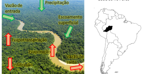
In our article “ Assessment of terrestrial water balance using remote sensing data in South America” we investigated the Amazon water cycle through a water balance approach. But what is water balance? Balanço hídrico é um método onde contabilizamos as saídas e entradas de água em um sistema – no nosso estudo, os sistemas são as bacias hidrográficas – por um determinado período (semanas, meses, anos). Por exemplo, na figura abaixo temos uma ilustração das saídas e entradas de fluxos de água representadas por setas, onde podemos quantificar o volume de água que entrou no sistema por meio da precipitação (chuva) e o que saiu pelo escoamento dos rios (vazão) e evapotranspiração da vegetação e dos solos. A diferença entre esses fluxos que entram e saem do sistema corresponde à variação do armazenamento de água.
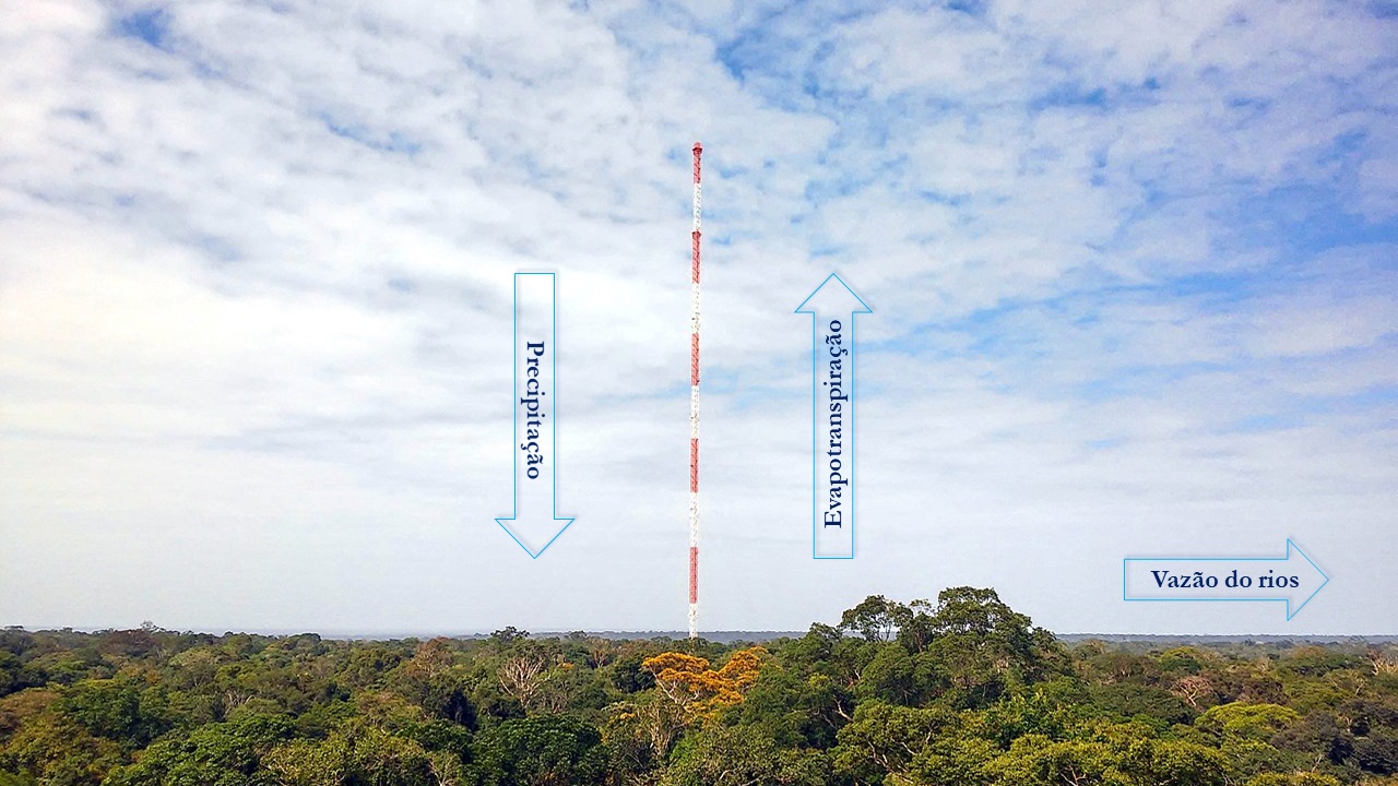
Water balance representation. The arrows indicate water inputs, through precipitation, and outputs, through river discharges and evapotranspiration, in the system. Figure adapted from the photo by Jorge Saturno (MPI-C), from the tower from Jorge Saturno (MPI-C) from torre do ATTO tower.
How can we estimate the water cycle variables for a basin, at long-term periods? As we mentioned before, many of these hydrological variables can be estimated by satellite data. In this study we used evapotranspiration data from two different sources, GLEAM and MOD16, precipitation data from TRMM and MSWEP, data from the GRACE mission to obtain terrestrial water storage changes, and field measurements of river discharges fromANA. We opted to use more than one source of data, for both precipitation and evapotranspiration because we know these satellite estimations have certain uncertainties. By using more than one source we could evaluate these datasets to verify which of them provide results with a better accuracy.
Based on the water balance approach we can estimate variables that are still hard to measure in the field or those which do not have high-density cover, such as river discharges. For instance, in our study, we computed the river discharges using only satellite data based on the water balance approach and compared the results with field river discharge measurements from ANA. Then we assessed the uncertainty of the satellite estimates. In the figure below we can see the uncertainty for river discharges indicated by the shaded area, for three large Amazonian river basins (Amazon, Tapajós, and Tocantins Rivers). In addition, we can also verify that the estimated river discharges based on satellite data (black line) are very close to ANA measurements (red line). Therefore, we were able to show that it is possible to estimate river discharges through the water balance, and the uncertainty associated with it.
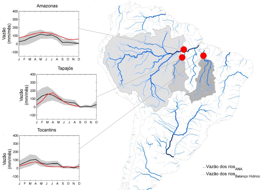
Estimation of river discharge’ seasonality with the water balance approach using satellite data (black line), and measured by the Brazilian Water Agency (ANA) (red line), for the Amazon, Tapajós, and Tocantins basins. Shadow area represents the uncertainty of runoff estimates.
Based on the water balance approach we can also improve our knowledge about how the precipitation and evapotranspiration regimes vary, providing information about past flood and drought events. However, this will be the subject of a next text!
It is essential that we understand the water cycle and develop methods to quantify its components. Studies such as the one presented here have reinforced the great potential of using satellite data to monitor, evaluate and quantify water cycle dynamics.
Science is done collaboratively
This study is part of the doctoral research carried out by Adriana Moreira, through the graduate program in Water Resources and Environmental Sanitation at the Hydraulic Research Institute (IPH / UFRGS), under the guidance of Professor Anderson Ruhoff. This research had financial support from the National Council for Scientific and Technological Development (CNPq), in partnership with the Coordination for the Improvement of Higher Education Personnel (CAPES) and with the Brazilian Water Agency (ANA).
Want to know more? Access the links below!
Builes-Jaramillo e Poveda (2018). Conjoint Analysis of Surface and Atmospheric Water Balances in the Andes-Amazon System. Water Resources Research. (Link)
Maeda et al. (2017). Evapotranspiration seasonality across the Amazon Basin. Earth System Dynamics. (Link)
Moreira et al. (2019). Assessment of terrestrial water balance using remote sensing data in South America. Journal of Hydrology. (Link)
Rodell et al. (2011). Estimating evapotranspiration using an observation based terrestrial water budget. Hydrological Processes. (Link)
Swann e Koven (2017). A Direct Estimate of the Seasonal Cycle of Evapotranspiration over the Amazon Basin. Journal of Hydrometeorology. (Link)

Adriana Moreira is an Environmental Engineer (FACET-MG), Master in Remote Sensing and PhD student in Water Resources and Environmental Sanitation (IPH/UFRGS). More information on Lattes and ResearchGate.

