Purus River Basin: observed from space and modelled on Earth
13 May 2021 | Duration of reading: 7 min
By Aline Meyer Oliveira
Experimentos são um elemento-chave para a pesquisa científica. Dependendo da área do conhecimento, os experimentos são conduzidos em tubos de ensaio, em supercomputadores, entrevistas a pessoas, entre outros. No caso da Hidrologia – ciência que estuda a dinâmica da água na natureza – é possível construirmos um pequeno rio no laboratório para realizar nossos experimentos, embora não seja comum. No entanto, é inviável que esse rio tenha 3,000 km de extensão (aproximadamente a distância de Porto Alegre, no Rio Grande do Sul, a Salvador, na Bahia), com uma planície inundável que pode chegar a 30 km de largura. Essas são as dimensões do rio Purus, na Amazônia. Os rios amazônicos são laboratórios incríveis e complexos para análise e compreensão da natureza. Embora não seja possível reproduzi-los na escala 1:1, nós podemos simulá-los no computador por meio de modelos hidrológicos.
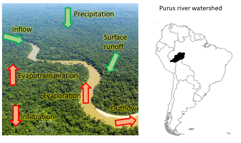
In hydrological models, we attempt to reproduce in the best possible way the (irreproducible) water cycle and its complex and countless interactions with nature, by using mathematical equations. These models are very useful for the compreension of hydrology through a river basin (see here an example of application of a hydrological model to represent the fluxes in South American rivers today). Some model characteristics, called “parameters", need to be adjusted (or calibrated), in a way that the streamflow in rivers in the model reproduce well the streamflow observed in monitoring stations (gauging stations). Even though streamflow might be well represented after calibration, that does not mean that all water fluxes in the model are well represented too. There are uncertainties related to the internal processes that the model represents: an amount of water that evaporated from the watershed can have erroneously been represented in the model by the water that actually infiltrated into the soil. Therefore, the evaporation in the model would be underestimated, and the infiltration overestimated (see the figure below). These uncertainties affect the hydrological model estimates, and this can hamper its uses for climate or land use change predictions, for example.

On the left, a simplified scheme of inflows (in green) and outflows (in red) of a hydrological system (in the background, image of Purus river, source: Shutterstock). On the right, Purus river location in the context of South America. Source: author.
In the research "On the contribution of remote sensing-based calibration to model hydrological and hydraulic processes in tropical regions", the goal was to investigate if satellite observations could aid in the parameter adjustment of hydrological models. To test whether this idea would work, we needed a huge watershed, whose variations in the water cycle could be noticed from space! The chosen “laboratory” was the Purus river, in Amazon.
Purus is a white-water river, also known as “muddy” water. Its headwaters are in Peru, and it extends to the Brazilian territory in large floodplains. Its landscape has little human activities, that is, it is considered conserved when we compare it to other landscapes in the Amazon. Using the Purus basin as a “laboratory” is a way of generating more precise, large scale information, in a region with little hydrological monitoring data. Besides, it is an unique opportunity for studies due to the natural complexity of this watershed.
Our work was based on remote sensing imagery. Remote sensing is more known by satellite imagery – those that we can see in Google Earth, for instance. But there are also satellites that “photograph” other aspects from Earth. These data are then fed into models, which after lots of calculation, are transformed into data that can be accessed by society (researchers, public agencies, etc). These data can be used to describe soil moisture, evapotranspiration, water level variations, water extent, among others variables. We observed 400,000 km2 of our “river-lab”, remotely, through the data provided by satellites.

Even though the Purus river was only “an experiment”, where we could test if the calibration with remote sensing imagery could improve the hydrological model predictions, we ended up finding out some interesting things about the local water dynamics. First, we calibrated the model with streamflow observations, and then we observed what the model was representing for other variables. When we looked at the evapotranspiration, the model results were too different from the satellite observations! Was it the model that was incorrect, or the satellite observations that were too noisy (that is, uncertain or with errors) for this region?

Time series results of model calibration with observations of streamflow and evapotranspiration. Source: adapted from Meyer Oliveira et al., 2021.
We looked for articles in the scientific literature, and we found out that other researchers had already reported the challenge of representing, in hydrological models, the amount of water that plants access in the soil (see this study). This happens because the Amazonian vegetation has longer roots, thus they can take up water from deeper layers of the soil all year long.
We verified that, when calibrating the model with evapotranspiration, the results for streamflow were a bit inferior, but the results for evapotranspiration were much better! Besides evapotranspiration, we also conducted these experiments for other variables, and we found results that the remote sensing observations can be of great use to reduce the uncertainties in hydrological model predictions, or even to aid in the estimation of hydrological variables in poorly-monitored regions.
Science is done collaboratively
This research is part of my Master’s work, which I developed in collaboration with the PhD candidate Ayan Fleischmann, under supervision of Prof. Rodrigo Paiva, at the Large Scale Hydrology Research Group, at the Hydraulics Research Institute, UFRGS. The complete work is published in the Journal of Hydrology. This research was funded by CAPES.
Want to know more? Access the links below!
Meyer Oliveira, A., Fleischmann, A. S., Paiva, R. C. D. (2021) On the contribution of remote sensed calibration to model hydrological and hydraulic processes in tropical regions. Journal of Hydrology (597). (Link)
Lettenmaier, D. P., Alsdorf, D., Dozier, J., Huffman, G. J., Pan, M., Wood, E. F. (2015) Inroads of remote sensing into hydrologic science during the WRR era. Water Resources Research 51 (9). (Link)
Hasler, N., Avissar, R. (2007) What controls evapotranspiration in the Amazon basin? Journal of Hydrometeorology (8). (Link)

Aline Meyer Oliveira is an Environmental Engineer graduated at UFRGS, with her Master’s in Water Resources at IPH/UFRGS. Curretly, she is a PhD candidate in the Hydrology and Climate (H2K) research group at the University of Zurich. Check out more at Lattes, ResearchGate or at sua página.
