What do the climate projections tell us about the water resources in the Amazon?
15 April 2021 | Duration of reading: 9 min
By João Paulo Brêda
Climate change has been a prominent theme in recent decades. This issue has been linked to the process of indiscriminate industrial development and ended up raising many environmental movements around the world. Political and inflammatory demonstrations brought debates that often disassociate themselves from science. Even though there is important research on the subject, there are still doubts and misinterpretations that lead to shallow, incoherent and biased discussions.
To begin, it is important to understand that climate variability is a natural process. On a scale of decades, we are faced with climatic phenomena such as El Niño and La Niña, which are related to temperature anomalies in the Pacific Ocean and significantly change the rain regime not only in the Amazon region but in several places in Brazil and the world ((more information about El Ninõ and La Ninã). On a scale of centuries and millennia, there are major climatic changes such as the appearance of ice ages (the latter 20,000 years ago) and other less abrupt periods such as the “Little Ice Age” between 1500 and 1800 d.c. For more information on paleoclimatology, see the texto by researcher Rafael Reis, which discusses the past climate in the Amazon region, published read more at Conexões Amazônicas.
However, the mobilization of scientists and world leaders consolidated through the IPCC IPCC (Intergovernamental Panel on Climate Change) highlights the human influence on the world climate. This is an attempt to reduce the effects on something that, unlike the natural climate variability, we have a certain responsibility. In urban areas, effects on climate due to anthropic actions are easily noticed, as is the case of thermal inversion and temperature increase due to the reduction of green areas (heat islands). On a global scale, the human effect on the climate comes down to consequences from greenhouse gases (GHG) emissions to the atmosphere. However, this effect is not so noticeable because it consists of a complex process that is mixed with natural variations that occurs between years, seasons, and due to specific atmospheric phenomena.
An alternative to detect and project these impacts is to use current scientific knowledge in the development of climate models. Climate models are mathematical tools that represent, in the form of physical equations, the balance of mass and energy that occurs in the atmosphere, oceans, soil and glaciers. They are able to simulate approximately the current climate of the planet and make predictions using projected concentration of GHGs in the atmosphere as input data. These models then provide climate information such as: temperature, rain, air humidity, atmospheric pressure, among others.
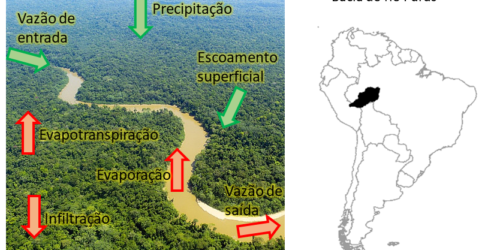
To obtain more accurate estimates of the impact on water resources, we forced a hydrological model with output data from climate models. With a similar concept, hydrological models use rainfall data as an input to simulate runoff, infiltration, evapotranspiration and soil moisture variation in river basins, and usually also estimate river flows. In the Figure 1 below we highlight the Amazon Basin, which is one of the study areas from our research about projections of climate change impacts on water resources related to the end of that century (2080-2100), a work carried out within the Large Scale Hydrology research group, at the UFRGS Hydraulic Research Institute (Link).

Figure 1. Main Hydrographic Basins in the Amazon region and their location in South America.
In this study, we used data from 25 global climate models in order to assess the uncertainties of the climate projections. The analysis is related to the scenario RCP4.5 which is one of the most used scenarios and represents a future with industrial development and GHG emissions under reasonable control.
Our results showed a considerable increase in the average annual temperature (between 2 and 3 oC), throughout the Amazon region, and a little lower in the western extreme of the basin, as we can see in Figure 2.
These results do not imply that some harsh winters and mild summers will cease to exist, as these are part of the natural variability, but maybe they will be less frequent. It is also observed that there will be a reduction in precipitation between 5 and 20% mainly in the eastern part of the basin and an increase in the extreme west (5 to 20% in the Andean region). Evaporation, on the other hand, will increase practically throughout the Amazon region, probably due to the expected increase in temperature and the large availability of water in the basin.

Figure 2. Change of Temperature, Precipitation and Evapotranspiration projected for the end of this century compared to nowadays.
The increase in evaporation combined with the decrease in precipitation causes a great reduction in streamflow, mainly in the eastern part of the basin. The runoff reductions are presented in Figure
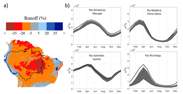
Figure 3. a) Map of the relative change of runoff projected for the end of the century compared to current days in the Amazon region. b) Hydrographs of some important basins in the Amazon. Black Line is the current discharge regime and the grey swath represents the inter-quartile distance related to the 25 climate models ensemble.
There is a great tendency to decrease the runoff, mainly in the eastern part of the Amazon basin, where the Xingu and Tapajós rivers are. We can see how the current streamflow (black line in the figure above) is well above the range of projections (in gray) generated by the hydrological model fed with climate data. This implies reductions of 10 to 20% in the waters flowing at the rivers Madeira, Amazon, Purus and even more than 30% of reduction in the Xingu and Tapajós rivers.
The results achieved in this study provide valuable information for the planning and management of natural resources. Given the current conditions of development, it is inevitable that engineering projects and resource planning consider information from climate projections. Otherwise, unwanted climatic effects will be common and may even have their impacts amplified.
Science is done collaboratively
This study was conducted by the Large Scale Hydrology research group, at the Hydraulic Research Institute of UFRGS. This work belongs to a project in partnership with INPE (Instituto Nacional de Pesquisas Espaciais) and financed by CAPES and ANA (Brazilian National Water Agency).
Want to know more? Access the links below!
Brêda, João Paulo Lyra Fialho, et al. “Climate change impacts on South American water balance from a continental-scale hydrological model driven by CMIP5 projections.” Climatic Change 159.4 (2020): 503-522. (Link)
IPCC, 2013: Climate Change 2013: The Physical Science Basis. Contribution of Working Group I to the Fifth Assessment Report of the Intergovernmental Panel on Climate Change [Stoker, T.F., Qin, G-K. Plattner, M. Tignor, S.K. Allen, J. Boschung, A. Nauels, Y. Xia, V. Bex and P.M. Midgley (eds.)]. (Link)
Global Climate Change. Vital Signs of the Planet. (Link)

João Paulo Brêda - Sanitary and Environmental Engineer of the Alagoas Federal University (UFAL). Master degree and current PhD student of Water Resourses and Environmental Sanitation at the Hydraulic Researchs Institute (IPH) of the Rio Grande do Sul Federal University (UFRGS).

